RTA installs signage, releases new system map to help riders navigate return to transit
June 8, 2021
June 8, 2021

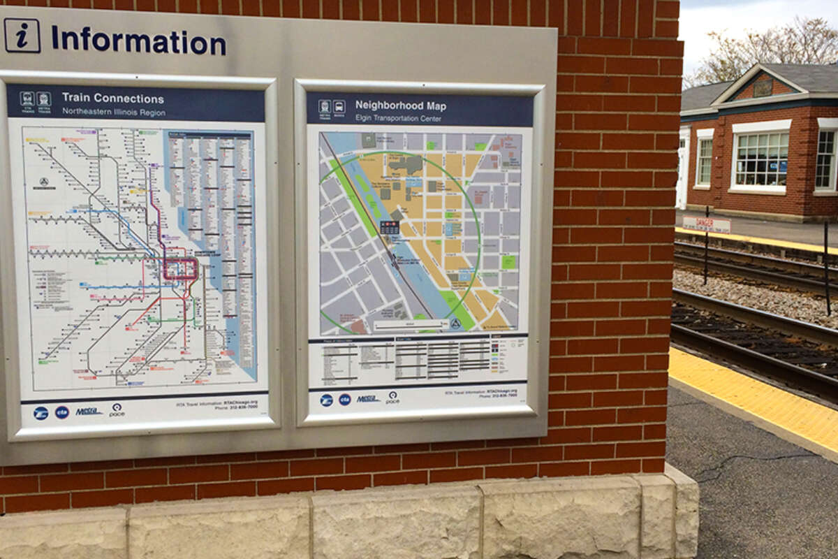
As riders return to CTA, Metra, and Pace following the pandemic, they can make use of new RTA-installed signage and an updated map to help navigate the region’s transit system.
A new system map, released in June 2021, includes the full routes for all three transit operators, accessibility information, ticket prices, and points of interest across the six-county RTA region.
Once riders are out in the region, they may notice some of the more than 1,000 signs installed by the RTA’s Interagency Signage program in recent years. Sign fabrication and installation continued throughout the pandemic to make transferring between the three transit agencies seamless and intuitive. The signs, which include wayfinding, system maps, route diagrams, and schedules, have been installed at 19 major transfer points in the region where CTA, Metra, and Pace services intersect.
The RTA’s sign program began in 2012 with a pilot program to use signage as a means for addressing the historic fragmentation of transit operations in the Chicago region, which includes buses and trains operated by three different agencies, private operators such as the railroads, and station properties that are owned by dozens of different government agencies or private entities. Mark Pitstick, a 22-year veteran of the RTA who created the interagency signage program said those delineations don’t matter to a rider who just wants to know how to get from Point A to Point B.
“We want to make it easy for people to travel throughout the region using transit,” Pitstick said. “It should be as convenient as possible for riders to get where they need to go.”
That sentiment was confirmed recently in a survey of current and lapsed riders released by the RTA in April 2021. Respondents were given a hypothetical investment of $10 to spend among several priorities for improving the region’s transit system. Riders, specifically those who have stopped riding during the pandemic, prioritized having better connections and a seamless travel experience between CTA, Metra, and Pace.
Read a recent report or explore an an interactive story map to learn more about where interagency signage has been installed in the past several years. Staff will present an update on the interagency signage program to the RTA Board at its June 17 meeting, which will be streamed on YouTube Live.
Pitstick said the program did not miss a beat during the pandemic. With stations emptier than normal, the RTA and its vendors were able to install signs at several locations last year, including:
Jefferson Park Transit Center in Chicago (CTA rail and bus, Metra, Pace)
This major transfer center includes adjacent stations on the CTA Blue line and the Metra UP Northwest line, plus two terminals for multiple Pace and CTA bus routes. The bus terminals, which host Pace’s new Pulse Milwaukee line, were recently rebuilt by the CTA. And all of this is located in the middle of, on top of, and next to the Kennedy Expressway, which makes making quick and easy wayfinding even more crucial.

Wheaton Metra station (Metra, Pace)
This interagency station on the Metra UP West line is served by five Pace bus routes. The UP railroad has three tracks at-grade to serve both Metra and freight trains, and Pace bus stops are located on both sides of those busy tracks. The signs and maps at this location help riders make the connections necessary to reach the nearby DuPage County government center and related public services in Wheaton.

Chicago Union Station (Metra, Amtrak, CTA rail and bus, Pace)
To complement the initial signs and maps that RTA previously installed at Union Station, in 2020 the agency added wayfinding signs along nearby sidewalks to help passengers make connections between Metra and Amtrak trains and other nearby transit services, including other Metra lines at Ogilvie Transportation Center and LaSalle Street Station, CTA trains at Clinton Blue Line and Quincy Loop stations, CTA and Pace buses at various nearby stops, and intercity buses at the Greyhound station.

Millennium Station (Metra, CTA rail and bus, Pace)
With entrances at both ends of the Metra platforms, Millennium Station is the terminus for the Metra Electric District and the NICTD South Shore Line. The CTA’s Brown, Green, Orange, Pink and Purple lines all serve the nearby Loop elevated station at Washington/Wabash. In addition, multiple CTA and Pace bus routes stop at several locations along Michigan Avenue, which is adjacent to Millennium Station. New wayfinding signs can help riders navigate transit near these busy tourist locations and find the accessible entrance on South Water Street.

All signs in the program are compatible with Americans with Disabilities (ADA) regulations.
Because the project was completed under budget, the $1.2 million remaining under the original $4.2 million federal grant will be used to expand to additional interagency locations in the region. Explore other recent accomplishments of the interagency signage program in an interactive story map.
Subscribe to our Newsletter
Related Articles
 One year in, Access Pilot Program makes transit more affordable, encourages ridership growth
This month the RTA, Metra, and Cook County are celebrating one year of success for the Access Pilot Program, which provides reduced fares on the entire Metra...
February 20, 2025 How to use transit to celebrate Black History Month in the Chicago region
Black History Month celebrates the rich cultural heritage, achievements, and diversity that are an integral part of our country, but often overlooked or supp...
January 27, 2025 How to use transit to get to the 2025 Chicago Auto Show
The Chicago Auto Show is the largest auto show in North America and one of the biggest annual events in the Chicago region. While it’s great fun to admire th...
January 27, 2025 How to use transit to celebrate the holidays in the Chicago region
Whether you’re looking to shop at holiday markets, attend festive performances, or take in all the sights the region has to offer, riding transit is the best...
November 18, 2024 How to use transit to get to Chicago area concert venues
As the birthplace of house and gospel music and a seedbed of blues and modern jazz, Chicago has always boasted a strong musical heritage. Today’s music scene...
November 7, 2024 How to use transit to enjoy fall in the Chicago region
Instead of mourning another Chicagoland summer come and gone, start creating your plans to make the most of fall. The RTA has curated a list of indoor and ou...
October 17, 2024